Share this post
In the remote, pristine rainforests of Suriname, communities face a choice: create the income they need through gold mining or through more sustainable measures.
On February 10, Rudo Kemper (Amazon Conservation Team), Niradj Hanoeman (an ADEK University student), and Keeng Koemoe (an indigenous cartographer from the village of Kwamalasamutu who helped produce one of ACT’s very first ethnomaps) traveled to villages along the upper Saramacca River to begin a two-year participatory mapping project with the Matawaai Maroons. Through the creation of maps, as well as additional training in entrepreneurship, handicrafts, and tourism, communities are taking the steps required to earn income that does not compromise their environmental and cultural priorities.

Boslanti, one of the most remote Matawaai villages (click to enlarge)
The Matawaai are descendants of formerly enslaved Africans who escaped from the coastal plantations and fought for their freedom some 250 years ago. A local foundation, Stichting Avittimauw, asked the Amazon Conservation Team (ACT) to train the Matawaai in mapping their traditional lands as part of a large-scale sustainable development initiative.
Ethnographic mapping has long been one of the central pillars of ACT-Suriname’s programs, so we accepted the opportunity with great enthusiasm. We knew the value this would create for the communities who could use maps to record important locations such as where to find seeds to make jewelry, interesting natural or historical areas that could be shared with tourists, and sacred sites important to community identity.
 conducts a training in Boslanti")
Niradj Hanoeman (ADEK) conducts a training in Boslanti (click to enlarge)
 explains how a GPS functions in Pusugrunu")
Keeng Koemoe (Kwamalasamutu) explains how a GPS functions in Pusugrunu (click to enlarge)
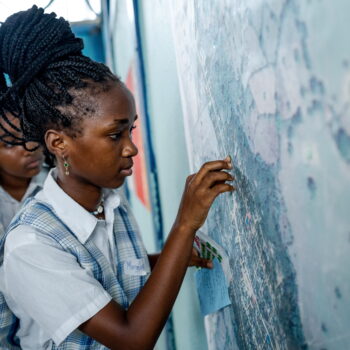
During the first phase of fieldwork, the team spent a month in 10 villages comprising the uppermost inhabited region of the Saramacca River. After receiving the approval of local leader granman Valentijn and the greater community, they conducted week-long training workshops in the villages of Pusugrunu and Boslanti, working with a diverse group of participants that included schoolteachers, elderly men and women, women agriculturalists, male hunters, and students. After preliminary participatory mapping workshops, the team trained participants in the use of GPS and piloted training exercises designed to teach participants to map their lands from their own perspective. In this way, communities can record areas where they hunt or fish, burial sites, and other areas of environmental and cultural importance. Together with ACT, community members completed initial maps for all of the villages, and the team loaned them 10 GPS units to continue the work in more detail.

Patricia and Albertina Flink learning how to use GPS during a training in Boslanti (click to enlarge)
Keeng, Niradj, and Rudo also undertook their own data collection while in the area. During the final week of their stay, they embarked on a four-day expedition with one elder: bassia William Anipa from the village of Pniel, whose intimate knowledge about Matawaai history and culture is well recognized by the community. They were also accompanied by three men in their 20’s: Sergio Van Aron, Miguel Emanuel, and Sersienjo Emanuel. As boatmen who head transportation of goods and people between villages, they know the area intimately. Together, the group gathered coordinates and local names for important landmarks and natural features along 100 kilometers of the Saramacca and Tukumutu rivers–important work because the knowledge of the local people (including the names of creeks, islands and rapids) has never been put on a map, and information about the visited stretch of Tukumutu has never been recorded.
 and Bassia William Anipa on the Tukumutu river")
Rudo Kemper (ACT) and bassia William Anipa on the Tukumutu river (click to enlarge)
In the coming months, the Matawaai will continue the mapping work, and representatives from ACT Suriname will return several times to conduct follow-up trainings and collect data. The goal is to produce a sophisticated, detailed, and accurate land-use map depicting the Matawaai lands from a local perspective by next year. The Matawaai will have ownership of this map, and will determine how it is used. The maps may be used to teach schoolchildren about tribal geography and history, collaborate with the government on land protection, begin tourist trips to the area, or train young hunters and agriculturists. Leaving the final decision to the Matawaai represents a key tenet of ACT’s work: we provide communities the skills they need to actively and autonomously design their future.